Tag: OSINT

No Time To Dispute: Russia’s A2/AD in the South Kurils

Remote and derelict, riddled with active volcanoes and disputed between Russia and Japan, the South Kurils make the perfect secret lair for any self-respecting evil genius. It’s no wonder the…

Remote and derelict, riddled with active volcanoes and disputed between Russia and Japan, the South Kurils make the perfect secret lair for any self-respecting evil genius. It’s no wonder the writers behind No Time to Die, the latest Bond film, chose the South Kurils as the setting for the film’s final act. While not directly named, the South Kurils are clearly referenced by Q’s description of Safin’s island – “part of a chain disputed between Russia and Japan.”

A closer inspection of the Russian military presence in the archipelago suggests [spoilers] that Q’s “donut” flight over the island could have ended poorly. Likewise, the Royal Navy’s HMS Dragoon would have probably faced immediate retaliation for its missile strike on Safin’s bioweapons facility. As for Bond, he didn’t just break our hearts, he also broke into Russia’s A2/AD bubble.


KEY JUDGEMENTS

I. Together with the rest of the archipelago, the southern Kurils form a natural barrier, protecting the Russian Pacific Fleet’s naval bastion in the Sea of Okhotsk from threats in the Pacific

II. Russia has significantly enhanced its posture in the South Kurils by deploying advanced air defense systems including the S-300VM4, several Su-35 air superiority aircraft, and coastal missile systems in the past decade. By establishing an anti-access/area denial (A2AD) zone in the South Kurils, Moscow signals to Japan that it will never forfeit its easternmost territory. 

III. Russia’s militarization of the South Kurils will continue in the coming years and focus on the archipelago’s largest islands. Plans for further investment suggest that the South Kurils will no longer be a semi-dormant military outpost but could “go active” for Russian operations in the West Pacific. 

FLASHPOINT: NORTHERN TERRITORIES OR SOUTH KURILS?

1. Disputed between Russia and Japan, the southern Kurils are the southernmost islands in the chain that separates the Sea of Okhotsk and the Pacific Ocean. More specifically, the southern Kurils consist of Iturup (Etorofu in Japanese), Kunashir (Kunashiri), Shibotan (Shikotan), and the Habomai islets. 

copyright Australian National University

2. Russia exercises de facto control over the islands, but Japan has a historical claim to them. The ongoing Russo-Japanese dispute prevents the two countries from signing a formal peace accord to end World War 2 and foster closer economic ties. The rest of the Kuril island chain is internationally recognized as Russian territory. 

  • RUSSIA: Russia calls the archipelago the “South Kurils” and administers it as a district (Yuzhno-Kurilsky) in the Sakhalin oblast. Over 7,000 km from Moscow and only 20 km from Japan, the South Kurils district is Russia’s easternmost territory. Russian control of the southern Kurils can be traced back to 1945 when the Soviet Union seized the archipelago from Imperial Japan. The Soviets planned to use the islands as a springboard to invade mainland Japan in competition with the US. 
  • JAPAN: Japan refers to the southern Kurils as “Northern Territories” and considers them part of Hokkaido prefecture. The Japanese settled and administered the southern Kurils centuries ago and have a series of bilateral treaties with Russia that recognizes Japan’s sovereignty over the islands. 

3. It is virtually certain that Russia will never concede the southern Kurils to Japan, despite the recent detente in bilateral relations. Moscow fears that conceding even a part of the Kurils could create a dangerous precedent for its territorial disputes in Eastern Europe and the Caucasus. While not at the top of the agenda, Tokyo is unlikely to shelve the southern Kurils dispute without significant concessions, such as free movement of Japanese fishers and/or demilitarization. However, there is a possibility, albeit low, that Russia might concede the Habomai islets and/or Shikotan islands to Japan as promised in an unratified 1956 Soviet-Japanese peace proposal.

SOUTHERN KURILS: BARRIER, GATEWAY, AND MINERAL DEPOSIT

4. BASTION BARRIER: While not strategic by themselves, the southern Kurils are critical components of the greater island chain, which serves as a natural barrier for Russia’s naval “bastion” in the Sea of Okhotsk. As a whole, the Kuril reef holds great military value from both defensive and offensive standpoints. 

  • DEFENSE: The Kurils can be flooded with air defense and coastal defense batteries combined with long-range artillery to keep adversaries at range. Invaders must adopt a costly leapfrogging strategy, contesting each island, if they wish to move surface vessels in the Russian Pacific Fleet’s Okhotsk bastion. 
  • OFFENSE: The USSR seized the South Kurils exclusively for offensive purposes in 1945. While military action against Japan is unlikely today (except retaliatory), the southern Kurils, particularly the Habomai islets, are valuable to monitor the US presence in Japan. 

5. GATEWAY TO PACIFIC: Russian naval movements indicate that the straits towards the southern Kurils are the Pacific Fleet’s most used passageways into the West Pacific. Even naval units based in Vladivostok and the Sea of Japan prefer to sail through the Kuril straits, via the Soya strait, over alternate routes (Tshushima and Tsugaru straits). The main reason is that the Kurils offer a more direct route to Alaska and the US mainland. Freedom of movement through the myriad of Kuril  straits is also important to diversify’s the fleet’s routes to and from the Pacific. Although some of the straits between South Kuril islands are difficult to navigate during winter due to ice formation.

6. RHENIUM: While underdeveloped, the south Kurils have always had some economic value. During the Cold War, it was fishing. Nowadays, rethium is the islands’ treasure – a rare earth element crucial for rocketry, aircraft production and the high-tech industry. Rhenium is widespread in the Kuril Islands, especially in the Kudryavyi volcano on Iturup. Given decades of underinvestment and poor infrastructure, Russia has barely tapped the islands’ mineral potential. 

GEOINT: RUSSIA’S A2/AD BUBBLE  IN THE SOUTH KURILS

South Kurils A2/AD (T-Intelligence)

7. Russia established an anti-access/area denial (A2/AD) in the southern Kurils throughout the past decade. The purpose of A2/AD is to deny adversaries freedom of action in a given theater and keep them at range. A combination of multi-layered air defenses and long-range strike platforms is the most common form of A2/AD composition, and the Kurils make no exception. 

  • AIR DEFENSE: By parrying a long-range S300VM4 with two short range systems (deployed in 2020), the Buk-M1 (d. 2012) and Tor M2 (d.?)Russia achieves a multi-layered air defense network that can monitor and threaten enemy aircraft. A variety of general surveillance and coastal radars are also likely based in the South Kurils. 
  • STRIKE PLATFORMS: Russia amassed the Bal and Bastion surface-to-surface missile systems (SSMs) to the Kurils in 2016. The Bal system (in Kunashir), and Bastion-P, (in Iturup), are capable of engaging both land and seaborn targets, and can be upgraded to accommodate newer missiles as they become available. 

ITURUP/ETORUFU

Overview: Locations of interest on Iturup/Etorufu Island (T-Intelligence)

Measuring 1,210 square miles (sq. m.), Iturup is by far the largest and most militarized island in the southern Kurils. Iturup absorbed the bulk of Russia’s military investment in the South Kurils with regard to hardware and infrastructure. Two airfields, a major infantry base, and several training grounds exist on Iturup. In the past decade, they have been modernized and expanded. Harbours and naval facilities have also improved over the years, but there is still no major naval base on Iturup. 

Russian forces have been sluggish in exploiting Iturup’s (dramatic) high ground for radar surveillance. There is also no visible progress on overhauling the islands’ WW2-era littoral defenses. Iturup’s fixed beach fortifications are overwhelmingly derelict. 

  • Burevestnik air base

Burevestnik Air Base on Iturup (T-Intelligence)

Built during WW2, then named “Tennet airfield,” Burevestnik is one of the largest airfields in the whole Kuril chain. The airfield hosted over 100 aircraft at the height of the Cold War. In 1965, the airstrip was extended to a length of 2,4 km, according to a declassified CIA assessment.  

In recent history, Burevestnik AB saw a significant all-around modernization. Nowadays, the airfield mainly hosts rotary-wing aircraft. The most notable improvement is the construction of an air defense site [44°55’7.77 “N 147°38’31.61 “E] dedicated to the S-300V4 systems (NATO reporting name: SA-23 Gladiator) that the Russia Eastern Military District deployed to Iturup in December 2020. Geolocation of the S-300’s first readiness exercise in Iturup to this location suggests that the air defense site was designed to host advanced hardware like the S-300. 

Geolocation of S-300 exercise in December 2020 to Burevestnik Air Base (T-Intelligence)

The air defense site and subsequent warehouse were built sometime between September 2012 and November 2015. Due to lack of open-source satellite imagery coverage before 2012, we could not pinpoint the exact timeframe. 

  • 18th Machine Gun Artillery Division [45° 2’3.68 “N 147°45’19.18 “E]

Temporal analysis of the 18th Machine Gun Artillery Division camp in Iturup shows significant infrastructure enhancement between 2005 and 2019 (T-Intelligence)

In the past, the base was a typical case of Soviet-era ghost military base. Still, imagery from August 2019 shows an explosive expansion and modernization of the military camp, especially compared to the previously available imagery from Google Earth from September 2005. The old and decayed buildings in the base’s midsection have been demolished and replaced with new, modern facilities. The base expanded eastwards, where a warehouse of interest, among other structures, emerged. A review of Planet’s RapidEye satellite imagery suggests that the warehouse was built in the second half of 2016. 

A GEOINT assessment conducted by Israeli company ImageSatIntl in July 2019 named the warehouse as a deployment site for coastal missile defense systems and identified two Rubezh systems (SSC-3) parked on the cement pad nearby. The newly deployed Bal (SSC-6) or Bastion (SSC-5) systems have likely replaced and retired the ageing Rubezh systems.  

  • Iturup Airport [45°15’28.50″N 147°57’16.53″E]:

Su-35 presence at Iturup airfield (T-Intelligence)

Built in 2014, Iturup airport (also known as Yasny) is a rare case of an entirely new facility constructed in the South Kurils. Iturup airport is also the first airfield to be built from scratch in post-Soviet Russia. With a 2,4 km airstrip and modern facilities, Iturup Airport is a dual-use airfield serving both civilian and military flights. In August 2018, Russia deployed three Su-35 air superiority (Flanker-E) aircraft to Iturup airfield. 

Image shows the three Su-35s on the Iturup airport’s apron in May 2020. Photo credits: Vera Bykova

  • Naval areas 

While the island does not host a military naval base, there are several noteworthy ports or small wharves that small vessels of the Russian Border Security Force (BSF) – Coast Guard or Russian Navy can use. Iturup’s coastline contrasts from flat beaches to sharp cliffs. Therefore artificial docking facilities, like wharves, are needed to accommodate vessels. 

  • Kurilsk Harbor [45°15’24.7 “N 147°52’55.9 “E]- Iturup’s largest port has seen significant modernization in the past years, which undoubtedly expanded Kurilisk’s military potential. 
  • LLC Fish processing plant and wharf [45°06’12.2 “N 147°41’53.0 “E]
  • “Autumn” fishing village [45°00’34.4″N 147°31’11.2″E]

KUNASHIR/KUNASHIRI

Overview of Kunashir island (T-Intelligence)

Kunashir is the second-largest island in the South Kurils (580 square miles). The island hosts a major airport (civilian) and a massive infantry base. Kunashir used to host a large naval Soviet presence in the Cold War, and was the assembly point for the Japanese Imperial surface group that attacked Pearl Harbor, according to a declassified CIA assessment. 

  • Yuzhno-Kurilsk Mendeleyevo Airport [43°57’42.17 “N 145°41’13.23 “E]

Mendeleyevo Airport in July 2021 via Google Earth (imagery: Maxar Technologies and CNES/Airbus)

With a 2,2 km airstrip and modest facilities, Mendelyevo has remained relatively unchanged in the past decade. The airport has seen limited modernization of auxiliary facilities but not expansion. Mendelyvo does not have a declared military role; however, if needed, it could support a limited number of fighter aircraft and helicopters for a short amount of time. Aeroflot subsidiary Aurora Airlines is the only commercial airline that flies to Mendelyevo. Aurora’s only route to Yuzhno-Kurilsk Mendeleyevo Airport is from Yuzhno-Sakhalinsk, and is mainly serviced by the company’s De Havilland Canada Dash 8-400 aircraft.

  • Seaport Yuzhno-Kurilsk 44°01’19.6 “N 145°51’15.7” E

Yuzhno-Kurilsk Seaport in April 2020 via Google Earth (image: Maxar Technologies and TerraMetrics)

Although mainly for civilian-commercial use, the Yuzhno-Kurilsk seaport has military significance. The wharf and docking facilities have likely once formed a “major Soviet naval base” as referenced in a declassified CIA report from 1955. While the coordinates provided in the CIA report are “broken,” pointing to an offshore location (happens to the best of us), Yuzhno-Kurilsk seaport is the island’s only naval facility and it is “near” the local airfield. A direct road links the two sites.

The seaport also hosts a fish processing plant and an offsite fuel storage facility, which are vital to the island’s economy and inhabitants. 

  • 46th Machine Gun-Artillery Regiment 44°03’19.3″N 145°47’06.2″E 

46th Machine Gun Artillery Regiment camp (T-Intelligence)

This Soviet-era installation bloomed starting in 2010 and nearly doubled after May 2017. New housing facilities, warehouses, and a host of small and medium-sized structures appeared during this timeframe. The constructors have also prepared approximately 120 square meters of parking areas, indicating an increase in troop and supply transportation vehicles.

A large, white hangar also emerged southeast of the parking lot for hosting advanced weapons capabilities (AWC), as the geolocation of the Bal systems in storage photo suggests. The image in question was obtained by a Japanese newspaper, Sankei, from a source on the ground. 

Leveraging the local high ground, two air defense sites exist north of the base. The first site, within the base’s limits, was built between 2015 and mid-2018. The layout is identical with the air defense site prepared at Burevestnik air base on Iturup, where the S-300VM4 resides. Google Earth’s latest imagery, dated April 2020, shows a probable surface to surface missile (SSM) system – either Bal or Bastion – positioned in the revetments, suggesting that the site is not exclusively for air defense. The second presumed air defense site (“high ground SAM site”) predates the recent modernization and has not hosted SAM activity in the past years, based on our review of available satellite imagery. 

A warehouse is also visible to the southeast, with vehicle marks suggesting pre-established routes to the nearby woodland – a possible shoot-and-scoot path. The warehouse and auxiliary areas were built between May 2017 and June 2018. As ImageSat International was the first to assess, the warehouse facility is identical with the one constructed at the 18th Machine Gun Artillery Division. This suggests a similar use, namely hosting advanced weapons capabilities (AWC). 


SHIBOTAN/SHIKOTAN

Overview Shikotan island (T-Intelligence)

Two noteworthy naval facilities exist on the archipelago’s third-largest island. While under civilian authority, Shibotan’s ports regularly – or permanently host – Russian Coast Guard vessels. No airfield exists on Shibotan. However, at least one helipad is visible at Malokurilskaya Bay [43°51’59 “N 146°49’39” E], and the island offers a host of adequate landing zones for helicopters. Infantry troops and likely an artillery unit are also based on the island. Declassified CIA reports from the 1950s claim that Shibotan hosted a Soviet frontier naval division, suggesting that this island played a crucial role in Moscow’s posture vis-a-vis Japan. 

  • Malokurilskaya Bay [43°52’29.5″N 146°49’23.5″E]

Geolocation of Russian Coast Guard vessels docked in Kunashir (T-Intelligence)

Geolocation of images posted on Russian forums underscores the Russian Coast Guard’s presence at Malokurilskaya Bay. The images suggest that the local Coast Guard unit (likely unit 2264 based on unverified crowdsourced information) is using the bay’s northern wharf as “home port” [43°52’25 “N 146°49’19” E].  

  • Trench line (derelict) [43°51’23″N 146°49’25″E]

Covering the hilly southern approach to Malokurilskaya Bay is a WW2-era trench fortification system accompanied by a slate of abandoned T-34, IS-2, and IS-3 tanks. If needed, the trench line could be revived as a stop-gap defensive measure, if overhauled, and reinforced with modern armored units. 

  • Krabovaya Bay [43°49’35″N 146°44’55″E]

This smaller port exclusively serves fishing activities, but its new, large wharfs make it adequate for small patrol craft to a certain extent. Large tonnage vessels are unable to reach due to shallow waters. Krabovaya Bay boomed after a private company built a new fish processing and storage plant and expanded the port docking facilities in 2019. 


HABOMAI ISLETS

Overview of the Habomai islets (T-Intelligence)

The closest to Japan’s Hokkaido province and the smallest landforms in the southern Kuril chain (39 square miles – combined), the Habomai are of little significance to Russia’s military posture. The islets’ rich waters are sought after by Japanese fishers, and Tokyo still hopes that it can recover the Habomai or establish a joint fishing zone in Habomai’s waters. The return of the Habomai (and Shikotan) to Japan was promised in the 1956 Soviet-Japan Joint Declaration, but the two parties failed to ratify the peace agreement. 

Except for two border outposts* and several defunct barracks and derelict fortifications, there are no noteworthy Russian installations or forces on the Habomai islets. Small boats and fast patrol craft of the Coast Guard regularly patrol the Habomai’s waters and arrest Japanese fishers. 

*Border post – Zelenoe Yuzhnokurilskiy [43 ° 30’9 “N 146 ° 5’23” E] 

*Border post – Muravyovka [43 ° 25’5 “N 145 ° 54’2” E]


OUTLOOK

8. Russia will further its force build-up by expanding the military infrastructure on Iturup and Kunashir, Russian Prime Minister Mishushtin announced in August 2021. Moscow said that it will build “51 more pieces of military infrastructure” in the Kurils, without detailing what kind of infrastructure this will be. We assess that most investments will likely upscale the logistics facilities and amenities of local units. Modern radars, point air defenses, and new naval facilities would greatly improve Russia’s local posture and are therefore strong candidates for the Kremlin’s upcoming investment plan. 

9. The growing A2/AD bubble in the South Kurils solidifies Russia’s grip on the disputed territories. It also dramatically reduces the likelihood of the islands, or parts of them, returning to Japan. Plans for further investment suggest that the South Kurils will no longer be a dormant military outpost but could “go active” and increase the pace of Russian operations in the West Pacific.


by HARM

Afterword: this strategic analysis (SA) does not encompass all *possibly* military-related sites and objects on the South Kurils as it prioritzed high value locations and advanced hardware. The SA’s purpose is to provide a succinct overview of the archipelago’s most noteworthy locations and highlight objects of interest. 

This assessment was made using Open-Source Intelligence (OSINT) techniques and resources. Visit Knowmad OSINT to learn more about our online OSINT training. 

Comments Off on No Time To Dispute: Russia’s A2/AD in the South Kurils

“Do Not Enter:” Using OSINT to Monitor Russia’s Wargames in the Black Sea

Russia has concentrated warships from all fleets, except the Pacific fleet, in the Black Sea for joint drills. While not unprecedented, it is rare to see such a show of…

Russia has concentrated warships from all fleets, except the Pacific fleet, in the Black Sea for joint drills. While not unprecedented, it is rare to see such a show of force.

The cross-theater deployments and large-scale exercises bear the hallmarks of a maritime build-up intended to intimidate Ukraine and deter NATO activities in the Black Sea.

This report showcases the Russian assets and maneuvers and analyzes how these actions are shaping the Black Sea theater of operations.


OBJECTIVE FEAR

Russia’s maritime build-up in the Black Sea has two aims:

  • intimidate Ukraine;
  • deter and complicate NATO activity in the Black Sea.

CROSS-THEATER DEPLOYMENTS

Russian naval task forces from the Caspian, Baltic and Northern Fleets have joined the Black Sea Fleet for exercises near Crimea.  

Caspian Flotilla: Around 15 vessels of the Capsian Flotilla, namely gunboats and landing crafts, entered the Black Sea on 16 April. 

Assets identified: 

  • 6x Project 11770 landing crafts (no. 721, 722, 723, 724, 725, 726) – NATO/AFIC reporting name: Serna-class.
  • 3x Project 1204 artillery gunboats (no. 042, 044, 045) – NATO/AFIC reporting name: Shmel-class.
  • 1x Project 16611 small hydrographic survey vessel (no. 01817).

The deployment was announced on 8 April but in a smaller number. The ships set sail on 11 April, with social media photos documenting their passage through the Don-Volga channel. Footage dated 16 and 17 April shows some of the Caspian task force vessels transiting the Kerch Strait that links the Sea of Azov with the Black Sea. 

OSINT map shows sail path of the Caspian task force (T-Intelligence 2021)

Baltic and Northern Fleets: Both fleets deployed Project 775, or Ropucha-class, landing ships to the Black Sea. Capable of carrying over 450 tones of hardware, primarily tanks or other vehicles, the Ropucha was purpose-built for beach landings. As a versatile hauling platform, the Ropucha has been Russia’s maritime logistical workhorse to deploy and support forces in Syria. 

Shispotters documented their northbound pass through the Bosphorus strait on 17 April.

Baltic Sea assets:

  • 2x Project 775 landing craft ( Kaliningrad no.102 & Korolev no.130) 

Northern Fleet assets: 

  • 2x Project 775 landing craft ( Kondopoga 027 & Alexander Otrakovsky 031) – NATO reporting name: Ropucha-class

The maritime build-up augments Russia’s land maneuvers near Ukraine’s border that have been ongoing for the past month. 

In addition to land and naval movements, Russia has also redeployed over 50 aircraft to Crimea. Ukraine estimates that Russia is now garrisoning nearly 110,000 troops near the Ukrainian border. 

MANEUVERS: COASTAL DEFENSE, AMPHIBIOUS ASSAULT

Russian forces in Crimea will hold a myriad of land, air, and naval exercises until 1 May. Some are already underway, while others will commence this week. 

The Russian drills have so far simulated the defense of Crimea and amphibious assaults of the enemy littoral – undoubtedly a message to Ukraine. Exercises involving marine and amphibious assaults are expected to continue. For example, in the next stage of a multi-phase campaign, Russian marines “will deliver artillery fire against a notional enemy’s coastal targets that will precede a seaborne assault on the shore.”

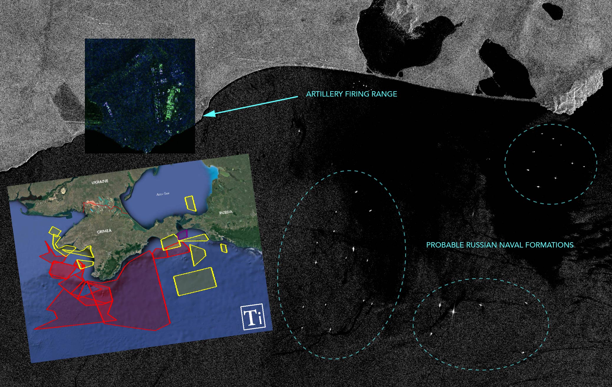
The satellite imagery below likely shows a Russian naval formation conducting a military exercise off the Crimean coast and near the Kerch Strait. Dated 19 April, the imagery was captured by the Sentinel-1’s synthetic aperture radar, a sensor that allows us to see through cloud cover.  The exercise area is covered by a notice to mariners (NOMAR) that Russia issued a few days ago. 

Sentinel-1 SAR satellite shows large and organized naval formation in a known Russian training area (T-Intelligence 2021)

The timelapse below shows the build-up of military hardware and logistics at the Opuk firing range. High-resolution imagery obtained by Der Spiegel provides a closer look at the staging ground.

Update: Monitoring the waters off Opuk, we have observed another spike in maritime activity on 21 April. The SAR imagery shows new Russian naval manoeuvres that are consistent with a coastal assault. With the exception of one search and rescue vessel (MMSI: 273145123), none of the ships were broadcasting AIS. No activity has been noticed on the previous day (April 20). 


New Russian maritime drills spotted on satellite imagery on 21 April (T-Intelligence)

Using visual evidence published by Zvezda TV on 22 April, we were able to confirm that these vessels and movements are connected to Russia’s exercises.

RUSSIAN NO-FLY/NO-SAIL ZONE?

As it is standard procedure, Russia issued a series of notice to airmen (NOTAMs) and notice to mariners (NOMARs) ahead of its exercises, informing seafears and pilots of which areas they should avoid. 

Map of NOTAMs and NOTMARs issued by Russia in connection to its military exercises in the Black Sea (T-Intelligence 2021)

Most “danger areas” are in effect until the end of April. However, in the Kerch strait, Russia plans to suspend the right of passage of foreign warships and “other state ships” until 31 October (purple rectangle). Russia’s state agency later claimed that “the planned restrictions will not affect navigation in the Kerch Strait or its entry points.” 

Russia’s temporary air-naval restrictions will have severe ramifications for maritime traffic to and from the Ukrainian port cities in the Azov sea, such as the strategic city of Mariupol. Russia’s de facto blockade of the Kerch strait will also prevent the Ukrainian navy, primarily based in Odessa, from reaching Mariupol in the event of a crisis.

In addition, Russia aims to deter NATO countries from even considering a “freedom of navigation” operation through the strait or a port visit on Ukrainian coast in the sea of Azov. However, the alliance has never suggested that it is considering such missions. 

DENYING NATO ISR ADVANTAGE?

Another key effect of Russia’s excessively large NOTAMs and NOMARs is that it could deter or significantly limit NATO’s ISR (Intelligence, Surveillance, and Reconnaissance) missions on Russia’s exercises.

U.S. and British reconnaissance aircraft have been intensively monitoring eastern Ukraine, Crimea, and Russia’s Black Sea for the past weeks. Drones and maritime patrol aircraft are surveilling Crimea’s coast daily up until 19 April, keeping a close watch on Russia’s build-up – read more about NATO’s ISR operations here.

Given the latest NOTAMs, NATO surveillance platforms could be targeted by Russian anti-air fire or electronic attacks. From a legal standpoint, Russia has no authority to restrict the regional airspace, as Crimea is still internationally recognized as Ukrainian territory and falls under the Kiyv flight information region (FIR). However, the Russian build-up displays a credible capability and threat. It remains to be seen if NATO ISR missions will continue, and if so, how. 

DETERRENCE TEST FOR NATO

The movement of extra-regional NATO vessels will also be indicative of whether Russia’s muscle-flexing and deterrence work. Two U.S. warships are currently on station in the Aegean Sea after President Biden abandoned plans to sail into the Black Sea, fearing that this move would provoke Russia. 

Despite Washington’s reluctance, London has instructed two Royal Navy warships, one Type 45 destroyer and one Type 23 anti-submarine frigate, to deploy to the Black Sea. It remains to be seen if London will go through with the plan in May and if the U.S. warships will continue to idle in Greek waters. 

One thing is certain, regional NATO countries and Ukraine would breathe easier knowing that advance British and American destroyers are in the Black Sea just in case Russia’s wargames turn out to be something else.  


by HARM

editing by Gecko

Update 23 April – added a new satellite image of Russian naval drills from 21 April and two explanatory paragraphs. 

Update 22 April – additional comments have been added on the paragraph about NOTAMs and NOMARs to clarify Russia’s perspective on its plans to limit navigation through the Kerch strait. 

Comments Off on “Do Not Enter:” Using OSINT to Monitor Russia’s Wargames in the Black Sea

Attack on Vienna: 9 Minutes of Terror (SOCMINT)

On 2 November 2020, at around 2000 CET, a gunman opened fire in downtown Vienna, killing four people and injuring 23. The Austrian special forces responded swiftly and neutralized the…

On 2 November 2020, at around 2000 CET, a gunman opened fire in downtown Vienna, killing four people and injuring 23. The Austrian special forces responded swiftly and neutralized the attacker approximately nine minutes after the shooting started. 

Hours before the attack, the gunman pledged allegiance to ISIS and terrorist leader Abu Ibrahim al-Hashimi al-Qurashi in an Instagram post. Like in similar cases, this enabled ISIS to take credit for the attack. 

THE GUNMAN

Austrian Police identified the gunman as Kujtim Fejzulai (KF), a 20-year old Austrian. He had Albanian roots and held both Austrian and Macedonian citizenships. 

KF was known to the Austrian Office for the Protection of the Constitution and Counterterrorism since 2018 when he attempted to travel to Syria to join ISIS. Turkish intelligence apprehended FK before he could cross the border and extradited him to Austria. FK was sentenced to 22 months in jail on terrorism charges but was paroled eight months later.  

In July 2020, KF traveled to neighboring Slovakia to buy ammunition for a Kalashnikov AK-47 assault rifle. He nevertheless returned empty-handed as he did not have a gun license. The Slovak police say they informed their Austrian colleagues immediately, which the Austrian Interior Ministry corroborates. 

Despite the tip-off from the Slovaks, the Austrians failed to exploit the intelligence and arrest the attacker. KF went free, attended radical mosques, and eventually procured weapons. FK also met with known foreign Islamists last summer – two from Germany who were under surveillance and two from Switzerland who have been arrested. 

THE OBJECTIVE

Neither the timing nor the target area was a coincidence. KF launched the attack four hours before new coronavirus restrictions came into effect. As the Viennese enjoyed a last night out, bars and restaurants were packed. 

The attack started near a Jewish Cultural Center on Seitenstettengasse, which was initially considered the gunman’s target. It became clear later that KF’s aim was broader. Thanks to Social Media footage and openly available mapping services, we can partially recreate the attacker’s path. 

THE ATTACK

1. Aprox. 20:00 hours (CET), Seitenstettengasse, 48°12’42.2″N 16°22’28.5″E

Tactical overview 1: Vienna gunman begins his rampage

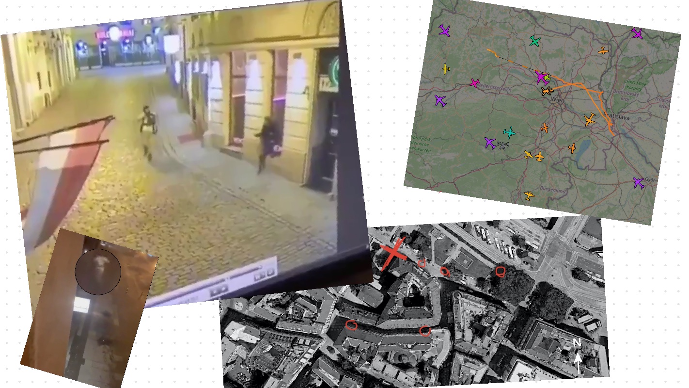
CCTV footage from the Jewish Cultural Center shows Fejzulai, armed with an AK-47, wearing a white robe and a ski mask, running down Seitenstettengasse. At approximately 20:00 CET, KF guns down his first victim in front of Meinz Cocktail Bar. 

 2. Aprox. 20:05, Schwedenplatz tram station, 48°12’43.5″N 16°22’33.8″E

Tactical overview 2: Gunfight between terrorist and police officers

The attacker appears again on social media. An eyewitness recorded a gunfight between the Austrian police and the terrorist at the Schwedenplatz tram station. The fire exchange resulted in the injury of one officer. The eyewitness filmed the gunfight from the 1st floor of the McDonalds across the street.

3. Aprox. 20:07, Stephandsom Strasse, 48.212196’’N, 16.375128’’E

Tactical overview 3: Gunman flees location of gunfight

An eyewitness video shows the gunman fleeing the gunfight scene via Stephandsom Strasse. KF passes in front of a Billa supermarket and a theatre before taking a left turn toward St. Ruprecht church, where he is ultimately gunned down by the police. 

4. Aprox. 20:09, St. Rupert’s Church, 48°12’43.6″N 16°22’28.6″E

Tactical overview 4: Tango down

The Austrian police guns down KF near St. Rupert’s Church. A photo shared on Twitter shows the suspect laid flat on the cobblestone.  

HUNT FOR SECONDARIES?

Initial reports indicated there were multiple active shooters. Social media photos show the arrest of several suspects. 

Austrian policemen arrest several suspects in connection with the ongoing security situation on 2 November 2020

Over the next few days, the Austrian authorities continued the hunt for potential accomplices through airborne patrols and follow-up raids. At least two helicopters were spotted on flight trackers, displaying behavior consistent with aerial surveillance.

Callsign “FLYCOM2,” operated by a private airborne monitoring company, surveilled the southern city of Graz and the Slovenian border. This sortie was very likely connected with follow-up counter-terrorist activities.  

Callsign “FLYCOM2” flying in a holding pattern over Graz before returning back to Slovenia (ADS-B Exchange screenshot)

The second helicopter flew with no identity and crossed into Slovakian airspace. The helicopter loitered over Bratislava before it returned to the Vienna metropolitan area. While we cannot tell with certainty who was operating the aircraft or what equipment it was carrying on board (SIGINT, IMINT), it is highly likely that this was also a follow-up counter-terror operation. 

“Anonymous” helicopter flies over Vienna after completing a sorties in Slovak airspace (ADS-B Exchange screenshot)

Austrian police also analyzed an estimated 20,000 video materials from eyewitnesses of the attacks, searched over 18 properties, and detained 14 persons believed to be connected with the gunman. 

Despite these efforts, the police have been unable to conclusively determine whether the gunman had any accomplices. 

THE AFTERMATH

KF’s attack marks the return of mass shootings in Europe after a period of relative calm. The Vienna shooting follows a series of terrorist attacks that have shaken France in recent weeks. 

There is reason to believe that ISIS might attempt to capitalize on the recent tempo and order or coordinate a new attack. However, given the group’s precarious situation in Syria and Iraq, it is unlikely that the “central leadership” will produce more than propaganda and calls to action to incite followers abroad. 

SITE Intelligence Group reports that ISIS propaganda has already launched a social media offensive earlier this month. Pro-ISIS media is inciting lone-wolf attacks against the West, with emphasis on Madrid and Paris

Another important lesson to draw from this attack is that no country, not even neutral ones like Austria that refrain from foreign intervention, are safe from jihadi terrorism.


T-Intelligence congratulates the Austrian security forces for enlisting the crowds’ help in the blitz chase for the shooter. At the height of the attack, the Viennese Police asked social media users to send images and videos related to the attack. User-generated content of the shooter posted on social media, proved to be valuable Open-Source Intelligence (OSINT) for live situational awareness, trial evidence, and forensics data.

Learn more about OSINT here.  


by HARM

Comments Off on Attack on Vienna: 9 Minutes of Terror (SOCMINT)

Type on the field below and hit Enter/Return to search